
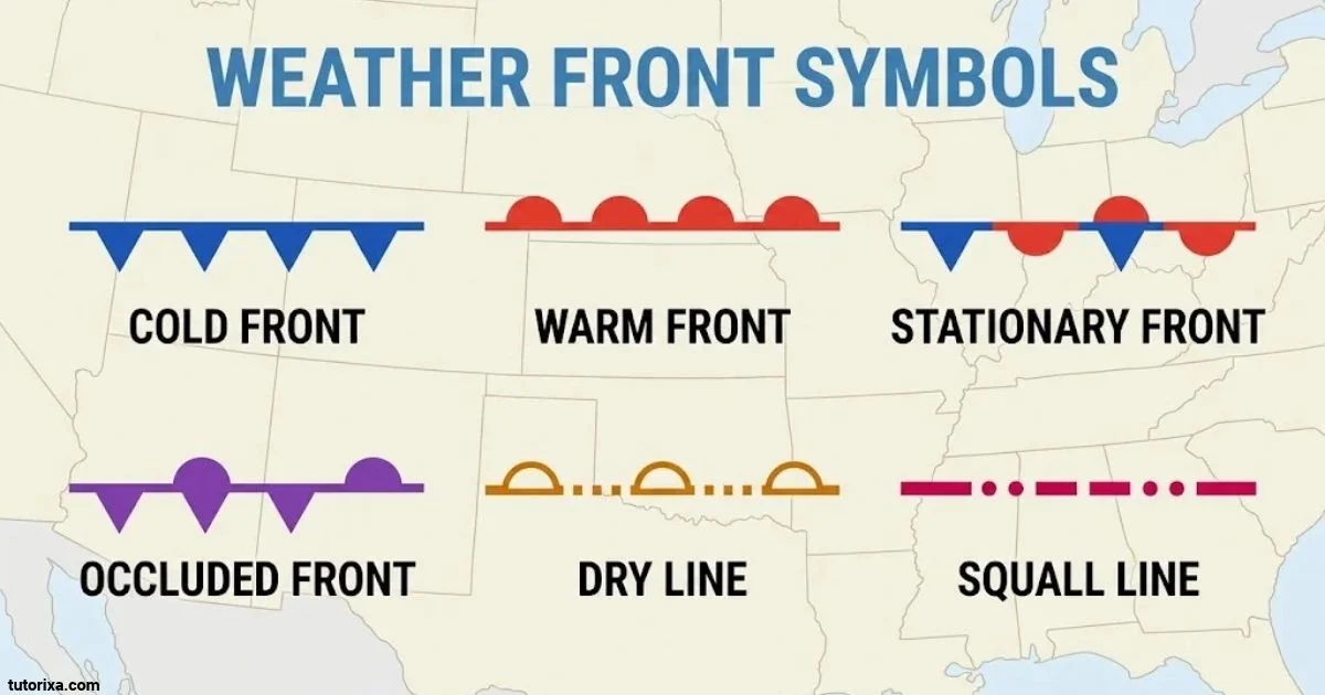
Weather front symbols help you understand what is happening in the atmosphere and what kind of weather may arrive next. You can find them on weather maps, forecast charts, and meteorological reports. Each symbol represents a different type of boundary between air masses.
The four main weather front symbols are cold fronts, warm fronts, stationary fronts, and occluded fronts. They use different colors and shapes, such as blue triangles, red semicircles, and purple combinations. Learning these symbols makes it easier to recognize changing weather conditions, including rain, thunderstorms, temperature changes, and cloudy skies.
In this guide, you will find a complete weather front symbols chart, the meanings of individual symbols, and examples of how they appear on weather maps. You will also learn how to read front lines and identify the direction in which weather systems are moving.
What Are The Weather Front Symbols?
A weather front is the boundary between two air masses with different temperatures and densities. When one air mass moves into an area occupied by another, it creates a front that can change local weather conditions.
Meteorologists use colored lines and special shapes to show these boundaries on weather maps. The shapes indicate the type of front, while their position and direction help explain how the weather system is moving.
The four main types are:
- Cold front: A blue line with triangles.
- Warm front: A red line with semicircles.
- Stationary front: An alternating red and blue line with symbols on opposite sides.
- Occluded front: A purple line with alternating triangles and semicircles on the same side.
These symbols are standard visual conventions used on many surface weather maps. They help meteorologists and weather watchers understand the movement of air masses without reading lengthy descriptions.
Weather Front Symbols And Meanings
Each weather front symbol represents a different interaction between warm and cold air. The color and shape make it easier to identify the front at a glance.
Here is a quick explanation of the four main symbols:
| Weather front symbol | Appearance | Meaning |
| Cold front | Blue line with triangles | Cold air replaces warm air. |
| Warm front | Red line with semicircles | Warm air replaces cold air. |
| Stationary front | Red and blue line with alternating symbols on opposite sides | Neither air mass is advancing significantly across the boundary. |
| Occluded front | Purple line with triangles and semicircles on the same side | A cold front has caught up with a warm front. |
What the shapes mean:
- Triangles: Represent a cold front and point toward its direction of movement.
- Semicircles: Represent a warm front and point toward its direction of movement.
- Alternating shapes: Show that two different frontal features are involved.
- Colors: Help distinguish the front types on standard weather maps.
Remember that the colors are map conventions, not actual colors found in the atmosphere. The symbols provide a simple way to identify different weather boundaries.
National Oceanic and Atmospheric Administration+1
4 Weather Front Symbols
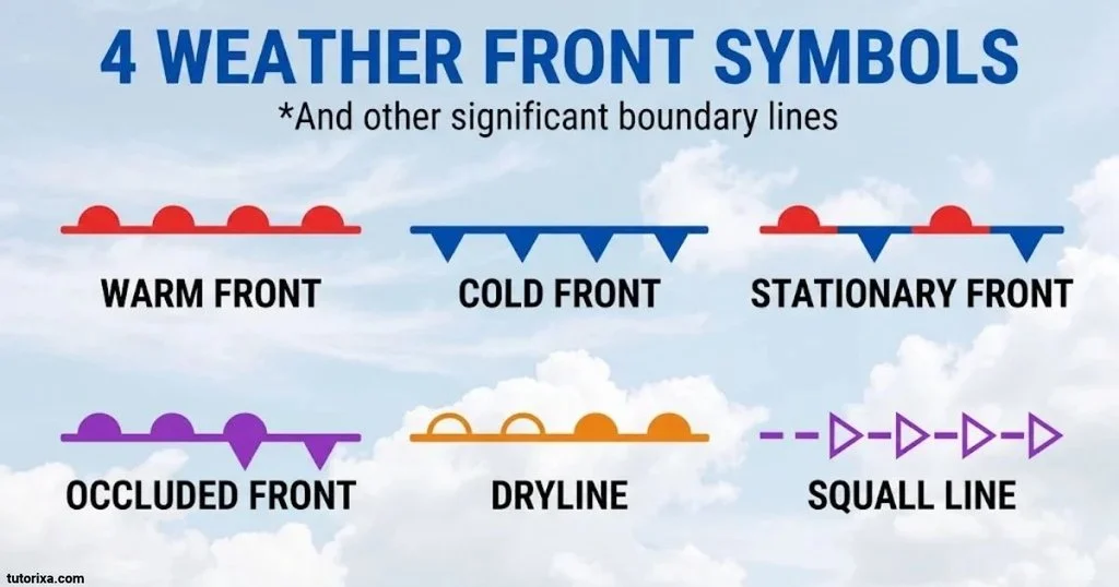
There are four main weather front symbols that you should learn if you want to understand weather maps.
Here is a closer look at each one:
1. Cold Front — Blue Triangles
A cold front forms when a colder, denser air mass advances and replaces warmer air. Its symbol is a blue line with triangles pointing in the direction of movement.
2. Warm Front — Red Semicircles
A warm front develops when warmer air advances and replaces colder air. It appears as a red line with semicircles pointing toward the direction of movement.
3. Stationary Front — Red And Blue Symbols
A stationary front forms when warm and cold air masses meet but neither moves forward significantly. Its map symbol has alternating red semicircles and blue triangles on opposite sides of the line.
4. Occluded Front — Purple Triangles And Semicircles
An occluded front forms when a cold front catches up with a warm front. Its symbol is a purple line with alternating triangles and semicircles on the same side.
These four symbols are the foundation of reading surface weather maps. Once you recognize them, you can quickly identify the type of front affecting a particular region.
All Weather Front Symbols
The main weather front symbols have several visual variations depending on the type of weather chart and the information being displayed.
The following table summarizes the most common front symbols and their identifying features.
| Front type | Line color | Symbol shape | Symbol position |
| Cold front | Blue | Triangles | One side |
| Warm front | Red | Semicircles | One side |
| Stationary front | Red and blue | Triangles and semicircles | Opposite sides |
| Occluded front | Purple | Triangles and semicircles | Same side |
You may also encounter additional frontal features and boundaries on professional weather charts:
- Cold Front: An advancing cold air mass.
- Warm Front: An advancing warm air mass.
- Stationary Front: A nearly motionless boundary between two air masses.
- Occluded Front: A boundary created when a cold front catches up with a warm front.
- Quasi-Stationary Front: Another term for a front that is nearly stationary.
- Frontolysis: The weakening or dissipation of a weather front.
- Frontogenesis: The formation or strengthening of a frontal boundary.
The first four are the main symbols to recognize when reading an ordinary surface weather map. The other terms describe additional frontal processes or variations rather than four more basic front symbols.
Surface fronts and precipitation areas/symbols+2
Weather Front Symbols Chart
A weather front symbols chart makes it easier to compare all four main types in one place. Instead of studying each symbol separately, you can use this chart as a quick reference.
| Symbol identification | Front name | Typical weather conditions |
| Blue line with triangles | Cold front | Showers, thunderstorms, gusty winds, and cooler air |
| Red line with semicircles | Warm front | Increasing clouds, widespread rain, and warmer air |
| Alternating red and blue line | Stationary front | Prolonged clouds and possible periods of rain |
| Purple line with both shapes | Occluded front | Clouds, precipitation, and changing weather |
Quick chart-reading tip: Look at the shape first and then check the color. Blue triangles identify a cold front, red semicircles identify a warm front, and the purple combination identifies an occluded front.
Weather conditions shown in the chart are common possibilities, not guaranteed results. Actual conditions depend on moisture, atmospheric stability, temperature differences, and other weather factors.
Weather Front Symbols Key
A weather front symbols key explains what the different lines, colors, and shapes represent on a map. You can use it as a legend when studying a weather forecast or meteorological chart.
Here is a simple reference key:
| Map feature | What it represents |
| Blue line | Cold front |
| Blue triangles | Direction of cold-front movement |
| Red line | Warm front |
| Red semicircles | Direction of warm-front movement |
| Alternating red and blue line | Stationary front |
| Purple line | Occluded front |
| Purple triangles and semicircles | Occluded-front movement |
| Triangle and semicircle on opposite sides | Stationary front |
| Triangle and semicircle on the same side | Occluded front |
One detail is especially useful: the direction in which the triangles or semicircles point shows the direction of frontal movement on standard maps.
A front line without its symbols may not provide enough information to identify the front type. Always check the complete map legend if you are using a chart from an unfamiliar weather service.
How To Read Weather Front Symbols
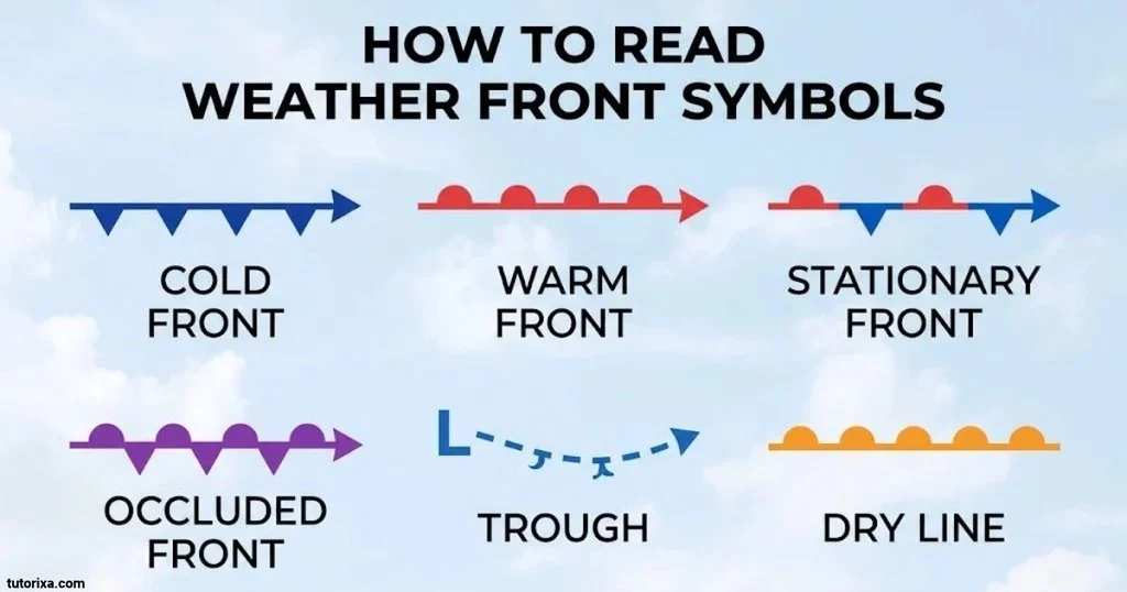
Reading weather front symbols becomes easier when you understand what each shape represents. You do not need advanced meteorology knowledge to identify the main fronts on a basic weather map.
Follow these steps:
Step 1: Identify the color.
Start by looking at the line color.
- Blue usually represents a cold front.
- Red usually represents a warm front.
- Purple usually represents an occluded front.
- Red and blue together usually represent a stationary front.
Step 2: Look at the shapes.
Check whether the line contains triangles, semicircles, or both.
- Triangles indicate a cold front.
- Semicircles indicate a warm front.
- Both shapes on opposite sides indicate a stationary front.
- Both shapes on the same side indicate an occluded front.
Step 3: Check the direction.
Look at the direction in which the triangles or semicircles point. On standard frontal symbols, these shapes point toward the direction the front is moving.
Step 4: Understand the possible weather changes.
After identifying the front, consider what weather it may bring.
- Cold fronts can produce showers, thunderstorms, and falling temperatures.
- Warm fronts can bring increasing cloud cover and widespread precipitation.
- Stationary fronts can cause extended periods of cloudy or rainy weather.
- Occluded fronts can bring a mixture of conditions associated with warm and cold fronts.
Step 5: Check other map information.
Look for high-pressure and low-pressure centers, precipitation areas, wind direction, and temperature readings. These features help you understand the larger weather system.
For example, if you see a blue line with triangles approaching your location, you are looking at a cold front. You can then check the surrounding forecast information to understand the possible effects.
Weather Front Symbols Map
Weather front symbols appear on surface weather maps that show the position and movement of different air masses. These maps help meteorologists explain current weather patterns and forecast upcoming changes.
On a typical weather map, you may find several different front lines connected to a low-pressure system.
Here is what to look for:
- Blue lines: Show cold fronts moving into warmer air.
- Red lines: Show warm fronts advancing into colder air.
- Red and blue lines: Identify stationary boundaries.
- Purple lines: Show occluded fronts where cold and warm frontal systems have combined.
A weather map may also display arrows, pressure readings, precipitation areas, and other meteorological information.
What Do The Symbols Tell You On A Map?
The symbols help you understand where different air masses meet and which direction a front is moving.
For example, a cold front moving toward a city may indicate an approaching change in temperature, wind, and precipitation. A stationary front near the same city may suggest that unsettled weather could remain in the area for some time.
However, a front symbol does not tell you the exact rainfall amount or temperature change. You need additional forecast information to understand those details.
You can explore official map examples and explanations through the NOAA surface weather maps guide.
Weather Chart Symbols And Meanings
Weather charts contain more than just front symbols. They also use other signs, letters, numbers, and lines to communicate atmospheric conditions.
If you look at a professional weather chart, you may encounter the following features:
| Weather chart symbol or label | Meaning |
| H | High-pressure area |
| L | Low-pressure area |
| Blue triangles | Cold front |
| Red semicircles | Warm front |
| Red and blue alternating line | Stationary front |
| Purple alternating symbols | Occluded front |
| Wind barbs | Wind direction and speed |
| Cloud-cover circle | Amount of sky covered by clouds |
| Rain symbol | Rain or precipitation |
| Snowflake | Snow |
| Lightning bolt | Thunderstorm or lightning |
| Fog symbol | Fog or reduced visibility |
| Trough line | An elongated area of relatively low pressure |
| Ridge line | An elongated area of relatively high pressure |
Weather Front Symbols vs. Other Weather Symbols
These two groups serve different purposes.
Weather front symbols identify boundaries between air masses. Other weather chart symbols describe conditions such as wind speed, cloud cover, precipitation, and atmospheric pressure.
For instance, a blue triangle line tells you that a cold front is advancing. A wind barb tells you about wind direction and speed at a particular observation point.
Understanding both types of symbols gives you a more complete picture of the weather.
Warm Front Symbol
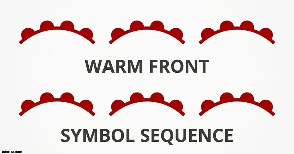
Symbol: Red line with semicircles.
Name: Warm front symbol.
Meaning: A warm air mass is advancing and replacing colder air.
The warm front symbol is one of the easiest weather symbols to recognize. It consists of a red line with small semicircles along one side.
A warm front forms when warmer air moves toward colder air and gradually replaces it at the surface. Because warm air is generally less dense, it rises over the colder air mass.
This gradual lifting can produce increasing cloud cover and widespread precipitation.
What Weather Does A Warm Front Bring?
A warm front often brings noticeable changes before it passes through an area.
Common conditions include:
- Increasing cloud cover.
- Light to moderate rain.
- Drizzle or fog.
- Gradually rising temperatures.
- A change in wind direction.
After the warm front passes, temperatures may become warmer, and rainfall may decrease.
Warm Front Symbol Meaning At A Glance
| Feature | Description |
| Color | Red |
| Shape | Semicircles |
| Air movement | Warm air advances |
| Direction | Semicircles point toward movement |
| Common weather | Clouds and widespread precipitation |
The red semicircles make this front easy to distinguish from the blue triangles used for cold fronts.
National Oceanic and Atmospheric Administration+1
Warm Front Symbol On A Weather Map
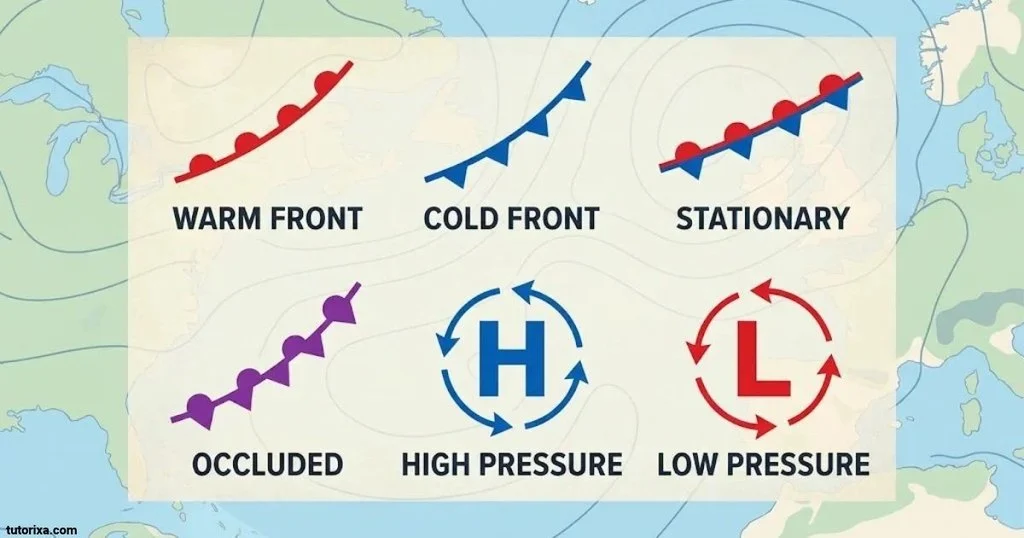
On a weather map, a warm front appears as a red line with semicircles extending from one side.
The semicircles point in the direction the warm front is moving. This helps you determine which area is likely to experience the advancing warm air.
For example, if the semicircles point northeast, the front is moving in that direction.
How To Identify A Warm Front On A Map
Look for these three features:
- A red frontal line.
- Repeated semicircular shapes along one side.
- Semicircles pointing toward the direction of movement.
You may also notice a low-pressure center nearby. Warm fronts commonly extend from low-pressure systems.
When a warm front approaches, clouds often become thicker and lower. Rain may begin before the front reaches a particular location because warm air rises gradually over the colder air ahead of it.
This is why a warm front can produce several hours of cloudy or rainy conditions.
Cold Front Symbol
Symbol: Blue line with triangles.
Name: Cold front symbol.
Meaning: A colder air mass advances and replaces warmer air.
A cold front forms when a colder, denser air mass moves into an area occupied by warmer air. The cold air pushes underneath the warm air, forcing it to rise.
This upward movement can create clouds, showers, and thunderstorms, especially when the warm air contains plenty of moisture and the atmosphere is unstable.
The cold front symbol uses a blue line with triangles along one side. Each triangle points toward the direction of movement.
What Weather Does A Cold Front Bring?
Cold fronts can produce noticeable weather changes over a relatively short period.
Common conditions include:
- Sudden showers or heavy rainfall.
- Thunderstorms.
- Strong or gusty winds.
- Falling temperatures.
- A change in wind direction.
- Clearing skies after the front passes.
The actual weather depends on the strength of the front and the surrounding atmospheric conditions.
Cold Front Symbol Meaning At A Glance
| Feature | Description |
| Color | Blue |
| Shape | Triangles |
| Air movement | Cold air advances |
| Direction | Triangles point toward movement |
| Common weather | Showers, storms, and cooler air |
A useful way to remember this symbol is to associate the blue color with cold temperatures and the triangular shapes with the advancing cold air.
Occluded Front Symbol
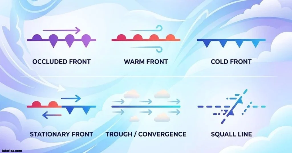
Symbol: Purple line with triangles and semicircles.
Name: Occluded front symbol.
Meaning: A cold front catches up with a warm front, lifting the warm air above the surface.
An occluded front forms when a faster-moving cold front catches up with a slower-moving warm front. As the two fronts combine, the warm air between them is forced upward.
This process is called occlusion. It commonly occurs during the later stages of a mid-latitude low-pressure weather system.
The symbol uses a purple line with alternating triangles and semicircles on the same side. Both shapes point in the direction of the front’s movement.
What Weather Does An Occluded Front Bring?
Occluded fronts can produce a mixture of weather conditions.
You may experience:
- Widespread cloud cover.
- Rain or snow, depending on temperature.
- Gusty winds.
- Changing temperatures.
- Unsettled weather near the frontal boundary.
There are two main types of occluded fronts:
Cold Occlusion: The air behind the advancing cold front is colder than the air ahead of the warm front. It pushes underneath the cooler air.
Warm Occlusion: The air ahead of the warm front is colder than the air behind the advancing cold front. The less-cold air is forced upward over the colder air.
Both types use the same general purple symbol on standard surface weather maps.
Occluded Front Symbol On A Weather Map
An occluded front appears as a purple line with alternating triangles and semicircles on the same side.
The same-side arrangement is the easiest way to distinguish it from a stationary front.
How To Recognize An Occluded Front
Check the following details:
- Look for a purple or magenta line.
- Find alternating triangles and semicircles.
- Confirm that both shapes appear on the same side.
- Check the direction in which the shapes point.
An occluded front is often connected to a mature low-pressure system. It indicates that the cold front has caught up with the warm front, lifting the warm air away from the ground.
The weather around an occluded front can include widespread clouds and precipitation. However, the exact conditions depend on the temperature and moisture of the air masses involved.
If you see purple triangles and semicircles together on one side of a line, you are most likely looking at an occluded front.
Stationary Front Symbol
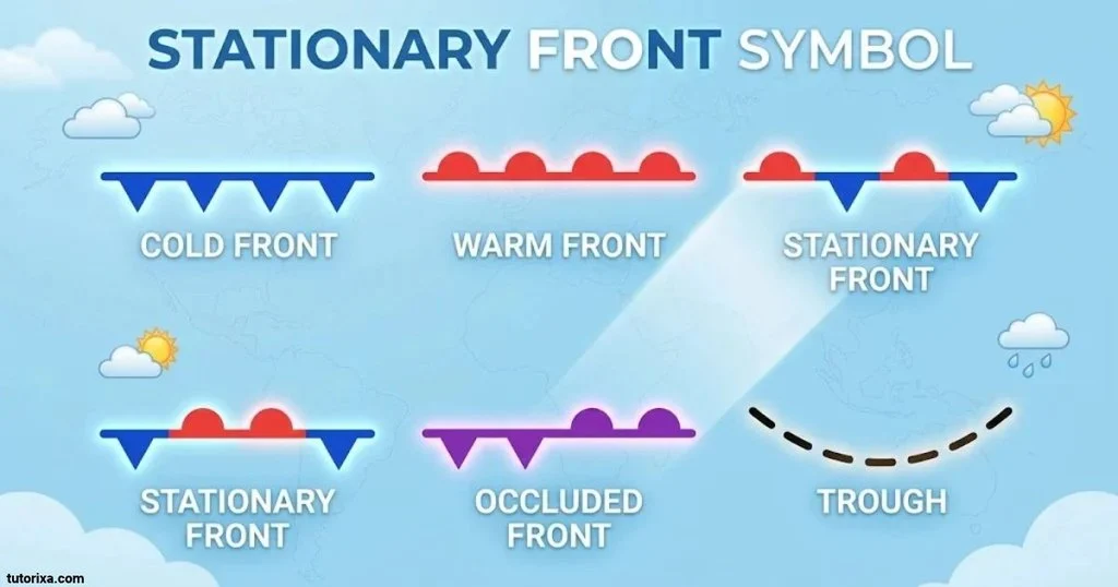
Symbol: Alternating blue triangles and red semicircles.
Name: Stationary front symbol.
Meaning: A boundary between warm and cold air masses that is moving very slowly or not at all.
A stationary front forms when two different air masses meet, but neither advances enough to replace the other. The boundary remains nearly in the same position for an extended period.
Its symbol combines the features of cold and warm fronts. Blue triangles appear on one side of the line, while red semicircles appear on the opposite side.
Unlike an occluded front, the two shapes do not point in the same direction. They face opposite sides of the boundary.
What Weather Does A Stationary Front Bring?
Stationary fronts can keep weather conditions unsettled in one region.
Common conditions include:
- Persistent cloud cover.
- Periods of light or moderate rain.
- Drizzle.
- Thunderstorms in favorable conditions.
- Extended wet weather.
If a stationary front remains in one area for several days, repeated rainfall may increase the risk of localized flooding.
Stationary Front Symbol Meaning At A Glance
| Feature | Description |
| Colors | Red and blue |
| Shapes | Semicircles and triangles |
| Shape placement | Opposite sides |
| Movement | Very slow or nearly stationary |
| Common weather | Clouds and prolonged precipitation |
A stationary front may eventually begin moving again. If colder air starts advancing, it can become a cold front. If warmer air begins advancing, it can become a warm front.
National Oceanic and Atmospheric Administration+1
Frequently Asked Questions
What Are The Four Main Weather Front Symbols?
The four main weather front symbols represent cold fronts, warm fronts, stationary fronts, and occluded fronts. They use blue triangles, red semicircles, alternating red and blue shapes, and purple combinations, respectively.
What Does A Purple Line Mean On A Weather Map?
A purple line with alternating triangles and semicircles on the same side represents an occluded front. It forms when a cold front catches up with a warm front.
Which Weather Front Symbol Uses Triangles?
A cold front uses a blue line with triangles. An occluded front also contains triangles, but combines them with semicircles on the same side of a purple line.
What Is The Difference Between A Stationary And Occluded Front?
A stationary front has red semicircles and blue triangles on opposite sides of its line. An occluded front has purple triangles and semicircles on the same side.
Do Weather Front Symbols Show The Direction Of Movement?
Yes. On standard weather maps, the triangles and semicircles point toward the direction in which the front is moving. This helps readers understand where the advancing air mass is heading.
Conclusion
Weather front symbols make it easier to understand how different air masses interact and influence weather conditions. The four main symbols represent cold fronts, warm fronts, stationary fronts, and occluded fronts. Each has its own color, shape, and meaning.
Learning to recognize blue triangles, red semicircles, and purple combinations can help you read weather maps more confidently. You can also use the weather front symbols chart and key as quick references whenever you study a forecast.
The most useful tip is to remember both the shape and the direction of each symbol. Once you understand these basic features, identifying weather fronts becomes much simpler, even if you are new to reading meteorological charts.

I’m Ellis Montgomery, a British writer interested in the powerful language of symbols. I explore everything from traditional emblems and cultural signs to contemporary symbols found in modern life. My aim is to explain their meanings clearly while revealing the stories and ideas behind them, making symbolism fascinating and accessible to everyone.
Books:
- The Complete Book of Symbols
- Hidden Messages in Everyday Symbols
 Rowan Whitaker
 Freddie Beaumont